Integrated models and geometry#
This part of the configuration defines the OPM Flow command, regional and reference grids, embedded site model, faults, reservoir geometry, and initial conditions.
OPM Flow command#
flow is a non-empty string containing the OPM Flow executable and simulator
flags. Do not add --output-dir because expreccs manages output directories.
If Flow is not on PATH, use its full path. An MPI launcher and any required
simulator options may be included in the same string.
flow = "flow --relaxed-max-pv-fraction=0 --enable-opm-rst-file=true --newton-min-iterations=1"
For supported simulator flags, see the OPM Flow command-line reference.
Regional model#
regional_dims defines the regional aquifer length, width, and depth in
metres. The origin is the lower-left corner. regional_x_n,
regional_y_n, and regional_z_n are variable refinement arrays for the
regional grid.
regional_dims = [45000, 15000, 81]
regional_x_n = [3, 5, 5]
regional_y_n = [5, 5, 5]
regional_z_n = [1, 1, 1]
Reference model#
The reference model represents the higher-resolution comparison solution.
reference_x_n, reference_y_n, and reference_z_n define its variable
refinement.
reference_x_n = [1, 1, 1, 5, 5, 15, 15, 15, 15, 15, 5, 5, 5, 5, 5]
reference_y_n = [25, 25, 25]
reference_z_n = [6, 5, 5, 5, 3, 3, 3, 3, 3]
Site model#
site_location defines the site box inside the regional model as
[xi, yi, zi, xf, yf, zf] in metres.
site_location = [18000, 5000, 0, 27000, 10000, 81]
Faults#
fault_regional defines the regional fault x and y positions, x and y
transmissibility multipliers, and vertical jump. fault_site defines the
initial and final x-y coordinates of the site fault and its transmissibility
multipliers. The site fault follows a zigzag path between its endpoints.
fault_regional = [10000, 11000, 0.01, 10, 22.5]
fault_site = [[21583, 5710], [24081, 8233], [0, 0]]
Layers and reservoir conditions#
thickness contains one thickness per layer in metres. pressure is the
reservoir-top pressure in bar, temperature contains top and bottom
temperatures in degrees Celsius, and rock_comp is rock compressibility in
inverse bar.
sensor_coords defines the x, y, and z position used to compare site and
reference results. z_xy is a Python expression for the reservoir surface as
a function of x and y.
thickness = [9, 9, 9, 9, 9, 9, 9, 9, 9]
pressure = 2E2
temperature = [60, 50]
rock_comp = 6.11423e-5
sensor_coords = [20000, 8000, 0]
z_xy = "(20-20*mt.sin((2*mt.pi*(x+y)/10000)))"
Generated grids#
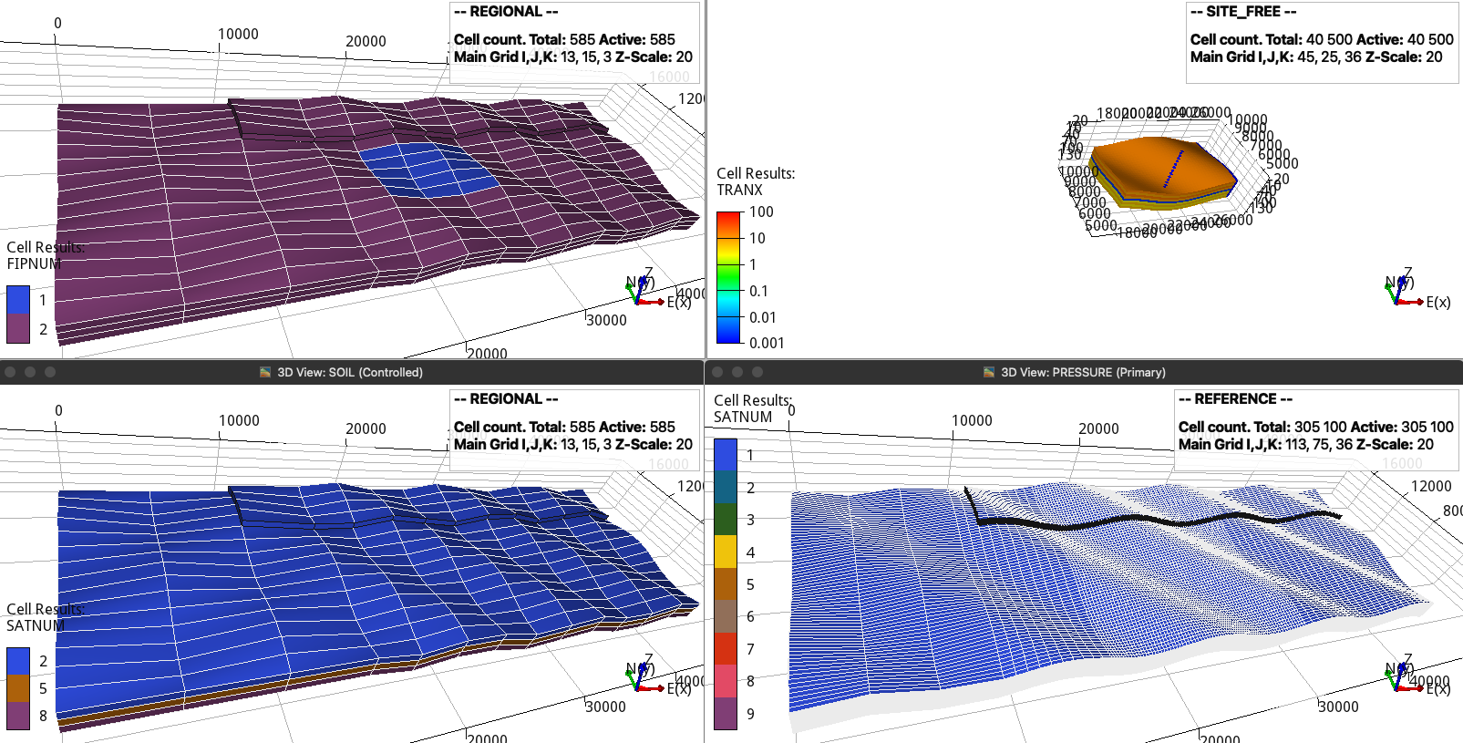
Site location in the regional model, the site fault, and the rock-property regions in the regional and reference models. The coarser regional cells retain the closest rock properties.#